Introduction
Hurricane Erin has taken center stage as the first hurricane of the 2025 Atlantic hurricane season, rapidly intensifying into a powerful Category 4 storm. Trending on Google and platforms like X, “Hurricane Erin” is capturing global attention due to its potential impacts on the Caribbean, Bermuda, and the U.S. East Coast. This copyright-free article provides the latest updates on Erin’s path, strength, and effects, along with essential safety information for affected regions.
Current Status and Forecasted Path
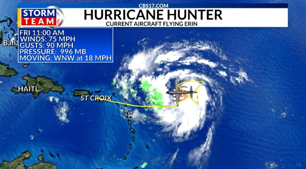
As of 6:00 PM IST (6:30 AM AST) on August 16, 2025, Hurricane Erin is a Category 4 hurricane with sustained winds of 130 mph, located approximately 415 miles east of the northern Leeward Islands at latitude 18.6°N, longitude 56.8°W. Moving west-northwest at 17 mph, the storm is expected to approach the northern Leeward Islands by Saturday evening, according to the National Hurricane Center (NHC).
Forecast models indicate Erin will maintain its west-northwest trajectory through Sunday, passing near or north of the Leeward Islands and Virgin Islands. By early next week, a northward turn is anticipated, potentially bringing Erin closer to Bermuda by Wednesday, August 20. While the U.S. East Coast is unlikely to face a direct hit, coastal areas should prepare for significant surf and rip current risks.
Strength and Rapid Intensification
Erin’s rapid intensification has been remarkable, escalating from a tropical storm with 45 mph winds on August 12 to a Category 4 hurricane with 130 mph winds by August 16. Warm sea-surface temperatures, low wind shear, and high moisture levels have fueled this growth, with the NHC forecasting a potential peak of 145 mph within 36 hours. However, increasing wind shear and possible eyewall replacement cycles may slightly weaken Erin thereafter, though it will remain a formidable hurricane.
Impacts Across Regions
Caribbean: Leeward Islands, Virgin Islands, and Puerto Rico
- Rainfall and Flooding: Erin’s outer bands are expected to deliver 2–4 inches of rain, with isolated areas seeing up to 6 inches, across the northern Leeward Islands, Virgin Islands, and Puerto Rico through Sunday. This raises concerns for flash flooding and landslides.
- Wind Conditions: Tropical storm watches are in place for Anguilla, Barbuda, St. Martin, St. Barthelemy, Saba, St. Eustatius, and Sint Maarten. Gusty winds are possible by Saturday evening, with tropical storm conditions expected in some areas.
- Surf and Swells: Life-threatening rip currents and swells are forecast, posing risks to coastal communities and beaches.
U.S. East Coast and Bahamas
While Erin is expected to stay offshore, the U.S. East Coast and Bahamas will experience dangerous surf and rip currents by August 19–22. Swells exceeding 10 feet could cause beach erosion and tidal flooding, particularly along the Atlantic coast and Chesapeake Bay. Florida residents may notice drier conditions midweek due to Erin’s influence.
Bermuda
Bermuda faces potential impacts by midweek, including strong winds, heavy rain, and high surf. Residents are urged to monitor updates from local meteorological services.
Recent Impacts in Cabo Verde
Erin, originating as a Cabo Verde hurricane, caused devastating flash flooding in São Vicente and Santo Antão earlier this week, with 7.5 inches of rain in São Vicente triggering significant damage and loss of life. This underscores Erin’s destructive potential even in its early stages.
Public Reaction and Trending Status
The term “Hurricane Erin” is trending on Google due to its status as the season’s first hurricane and its rapid intensification. On X, users like @NHC_Atlantic and @WeatherNation have shared updates on Erin’s Category 4 strength and potential impacts, driving public interest. The storm’s trajectory through popular tourist destinations like the Caribbean and Bermuda has further amplified online engagement.
Safety and Preparedness Tips
- Caribbean Residents: Secure outdoor items, stock emergency supplies, and avoid flood-prone areas. Stay updated via NHC advisories at www.nhc.noaa.gov.
- U.S. East Coast: Exercise caution at beaches due to rip currents. Follow local weather alerts and avoid swimming in hazardous conditions.
- Bermuda: Prepare emergency kits and monitor local weather updates for potential impacts by midweek.
- General Tips: Use apps like FEMA or NOAA Weather for real-time alerts. Consider practical solutions like filling a washing machine with ice to serve as a cooler during outages.
Why This Matters
The 2025 Atlantic hurricane season is predicted to be above-average, with 13–18 named storms expected. Erin’s early emergence as a Category 4 hurricane highlights the season’s potential intensity. Its trending status reflects public concern about its impacts on travel, safety, and infrastructure in vulnerable regions.
Conclusion
Hurricane Erin, the first major storm of the 2025 Atlantic season, is a powerful Category 4 hurricane with significant implications for the Leeward Islands, Puerto Rico, Bermuda, and the U.S. East Coast. As it trends on Google and X, residents in affected areas should stay vigilant and follow NHC updates. This copyright-free article, licensed under Creative Commons CC BY-SA 4.0, can be freely republished with attribution to ensure widespread access to critical information.


